ANELLO BASSO DELLA VERNA
un itinerario intorno al monte dove San Francesco ricevette le stimmate


Italiano


MAPPA DEL PERCORSO
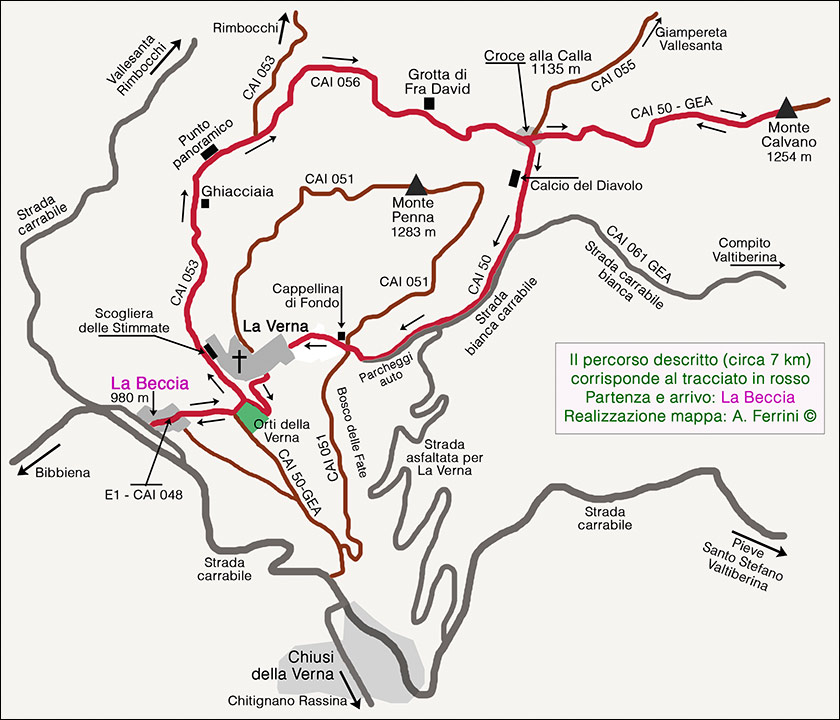

Mappa dell’itinerario Anello basso della Verna, detto anche Percorso della Ghiacciaia (segnato in rosso). Percorso non impegnativo (tranne la salita al Monte Calvano che si può evitare) di circa 2,5 ore di cammino. L’escursione gira intorno al sacro monte. Inizia dall’abitato Beccia. Agli orti della Verna volta a sinistra sul CAI 053. Dopo 200 metri passiamo sotto l’affascinate Scogliera delle Stimmate, quindi entriamo nella Foresta Sacra. Incontreremo la Ghiacciaia, un frigorifero naturale tra le rocce, quindi ci troveremo in una radura che ci offre un bel panorama sul Casentino. Appena rientrati nel bosco, il CAI 053 volge a sinistra per scendere all’abitato di Rimbocchi. Noi continueremo a destra sul CAI 056 che ci farà attraversare un bosco da favola e passerà accanto alla Grotta di Fra David. Appena usciti dal bosco siamo al quadrivio di Croce alla Calla. Proseguendo dritto sul CAI 50 GEA in circa 40 minuti di salita abbastanza impegnativa giungiamo sulla cima del Monte Calvano che ci offre bellissimi panorami. Se non vogliamo affrontare quest’ultimo sforzo a Croce alla Calla voltiamo a destra. Il CAI 50, dopo essere passato sotto il Calcio del Diavolo, ci porta in circa mezz’ora al Santuario Francescano. Dopo aver visitato questo sacro luogo, usciamo dall’antica porta. Oltre questa troviamo la strada lastricata che scende a La Beccia, punto di partenza della nostra escursione. La mappa riporta, segnati in marrone, altri due splendidi itinerari su questo monte. Uno è l’Anello alto della Verna, che dal santuario ci fa salire a La Penna, la cima del monte che ci offre un panorama mozzafiato. L’altro percorso è l’Itinerario Natura, altro percorso ad anello che da Chiusi della Verna ci porta al santuario facendoci conoscere il Bosco delle Fate, un vero luogo incantato.
Map of the itinerary Lower Ring of La Verna, also known as the Path of the Ice House (marked in red). Not demanding route (except the climb to Monte Calvano which can be avoided) of about 2.5 hours of walking. The excursion goes around the sacred mountain. It starts from the town of Beccia. At the orchards of La Verna turn left onto CAI 053. After 200 meters we pass under the fascinating Cliff of the Stigmata, then we enter the Sacred Forest. We will meet the Ghiacciaia, a natural refrigerator among the rocks, then we will find ourselves in a clearing that offers us a beautiful view of the Casentino. As soon as you return to the woods, CAI 053 turns left to go down to the village of Rimbocchi. We will continue to the right on CAI 056 which will lead us through a fairytale forest and will pass by the Grotta di Fra David. As soon as we come out of the woods we are at the crossroads of Croce alla Calla. Continuing straight on the CAI 50 GEA in about 40 minutes of a fairly demanding climb we reach the top of Monte Calvano which offers us beautiful views. If we do not want to face this last difficulty in Croce alla Calla we turn right. The CAI 50, after passing under the Calcio del Diavolo, takes us to the Franciscan Sanctuary in about half an hour. After visiting this sacred place, we leave the ancient gate. In addition to this we find the paved road that goes down to La Beccia, the starting point of our excursion.
The map shows, marked in brown, two other splendid itineraries on this mountain. One is the High Ring of La Verna , which takes us from the sanctuary to La Penna, the top of the mountain that offers us a breathtaking view. The other route is the Nature Itinerary , another circular route that from Chiusi della Verna leads to the sanctuary, making us cross the Bosco delle Fate, a truly enchanted place.
Ilbelcasentino.it è una realizzazione di:


Ilbelcasentino.it è una realizzazione di:
Alessandro Ferrini, 52010 Talla (AR) - P.Iva 01428280513
Tel. 339.4257840 - info@ilbelcasentino.it
Tutti i diritti riservati