Carda
in Casentino, una bella valle Toscana che puoi conoscere in ogni suo dettaglio con questo sito
Italiano
COLLEGAMENTO TRA CARDA E SANTA TRINITA
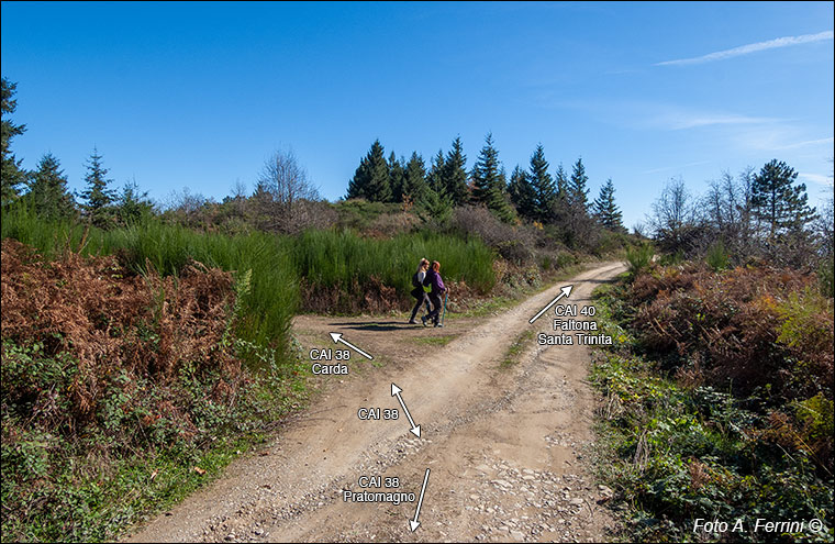
Dai prati del Pratomagno (zona Cima Bottigliana), dopo circa 3 chilometri di cammino sul CAI 38 siamo giunti in questo punto del crinale di Passo alla Forca dove il CAI 38 volta a sinistra per scendere a Carda in 4,2 chilometri. Andando a dritto entriamo sul CAI 40 che si dirige verso Faltona. Dopo ottocento metri giungiamo a Passo alla Forca (1065 m). Qui troviamo, a destra, il CAI 44 che in settecento metri scende a Badia Santa Trinita (952 metri).
Carda e Santa Trinita ebbero un forte legame fin dalla seconda metà del XIV secolo. A pagina 2 di questa sequenza è mostrato Passo alla Forca, valico di collegamento tra questi due luoghi, e spiegato il rapporto e la viabilità antica che li univa.
From the Pratomagno meadows (Cima Bottigliana area), after about 3 kilometers of walking on CAI 38 we have reached this point on the ridge of Passo alla Forca where CAI 38 turns left to descend to Carda in 4.2 kilometers. Going straight we enter CAI 40 which heads towards Faltona. After eight hundred meters we reach Passo alla Forca (1065 m). Here we find, on the right, CAI 44 which in seven hundred meters descends to Badia Santa Trinita (952 meters).
Carda and Santa Trinita have had a strong bond since the second half of the 14th century. On page 2 of this sequence, Passo alla Forca is shown, a pass connecting these two places, and the relationship and ancient road system that united them are explained.


