Carda
in Casentino, una bella valle Toscana che puoi conoscere in ogni suo dettaglio con questo sito
Italiano
CARDA, PAESE TRA I MONTI
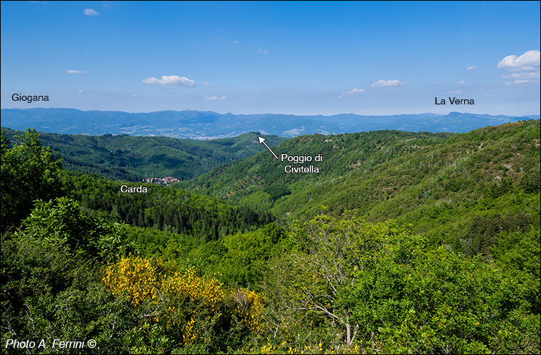
Ci troviamo a poca distanza da Passo alla Forca, a 1100 metri di altitudine. Siamo qui giunti da Castelnuovo di Faltona percorrendo il CAI 40, una strada carrabile (con mezzo adeguato) che scorre sul crinale che in linea di massima segna il confine tra i Comuni di Talla e Castel Focognano (possiamo giungere qui anche da Calleta). Da questa zona abbiamo panorami sia verso Arezzo, sia verso il Casentino. L'immagine sopra mostra proprio una vista verso questa valle e ci serve per capire dove è situato geograficamente il piccolo borgo di Carda che vediamo come "smarrito" sulle pendici dei Pratomagno.
All'orizzonte vediamo il crinale appenninico che segna il confine tra Casentino (Toscana) e Romagna. A destra distinguiamo l'inconfondibile "Crudo Sasso" della Verna, al centro della foto vediamo Poggio Spillo (zona Camaldoli - Badia Prataglia), a sinistra vediamo l'inizio della così detta Giogana, quel tratto di crinale appenninico che da sopra l'Eremo di Camaldoli giunge fino al Passo della Calla, citato come "Gran Giogo" da Dante nel V Canto del Purgatorio.
Di particolare importanza storica è il crinale posto sopra Carda. Questo, per qualche secolo, fino a metà Trecento, rappresentò il confine tra il territorio dei Guidi, oltre il crinale, e quello del Vescovado di Arezzo, al di qua. Poi, nell'arco di tre decenni, divenne tutto dominio fiorentino. Poggio di Civitella fu la sede di un importante castello (ci sono ancora i ruderi) per il controllo del territorio che appartenne ad una famiglia aretina vicino agli Ubertini.
Sul crinale sopra Carda scorre una storica strada (oggi CAI 31) che da Pieve di Socana sale a Poggio Masserecci e Pozza Nera, una zona del Pratomagno che vedremo a pagina 37 di questa sequenza. We are located a short distance from Passo alla Forca, at 1100 meters above sea level. We arrived here from Castelnuovo di Faltona along the CAI 40, a road suitable for vehicles (with an adequate vehicle) that runs along the ridge that marks the border between the municipalities of Talla and Castel Focognano (we can also get here from Calleta). From this area we have views both towards Arezzo and towards Casentino. The image above shows a view towards this valley and helps us understand where the small village of Carda is geographically located, which we see as "lost" on the slopes of Pratomagno. On the horizon we see the Apennine ridge that marks the border between Casentino (Tuscany) and Romagna. On the right we can see the unmistakable "Crudo Sasso" of La Verna, in the center of the photo we see Poggio Spillo (Camaldoli - Badia Prataglia area), on the left we see the beginning of the so-called Giogana, that stretch of the Apennine ridge that from above the Camaldoli Hermitage reaches up to the Passo della Calla, cited as "Gran Giogo" by Dante in the V Canto of Purgatory. Of particular historical importance is the ridge located above Carda. This, for a few centuries, until the mid-fourteenth century, represented the border between the territory of the Guidi, beyond the ridge, and that of the Bishopric of Arezzo, on this side. Then, over the course of three decades, it became entirely Florentine dominion. Poggio di Civitella was the site of an important castle (the ruins are still there) for the control of the territory that belonged to an Arezzo family near the Ubertini. On the ridge above Carda runs a historic road (now CAI 31) that goes from Pieve di Socana up to Poggio Masserecci and Pozza Nera, an area of Pratomagno that we will see on page 37 of this sequence.
Sul crinale sopra Carda scorre una storica strada (oggi CAI 31) che da Pieve di Socana sale a Poggio Masserecci e Pozza Nera, una zona del Pratomagno che vedremo a pagina 37 di questa sequenza. We are located a short distance from Passo alla Forca, at 1100 meters above sea level. We arrived here from Castelnuovo di Faltona along the CAI 40, a road suitable for vehicles (with an adequate vehicle) that runs along the ridge that marks the border between the municipalities of Talla and Castel Focognano (we can also get here from Calleta). From this area we have views both towards Arezzo and towards Casentino. The image above shows a view towards this valley and helps us understand where the small village of Carda is geographically located, which we see as "lost" on the slopes of Pratomagno. On the horizon we see the Apennine ridge that marks the border between Casentino (Tuscany) and Romagna. On the right we can see the unmistakable "Crudo Sasso" of La Verna, in the center of the photo we see Poggio Spillo (Camaldoli - Badia Prataglia area), on the left we see the beginning of the so-called Giogana, that stretch of the Apennine ridge that from above the Camaldoli Hermitage reaches up to the Passo della Calla, cited as "Gran Giogo" by Dante in the V Canto of Purgatory. Of particular historical importance is the ridge located above Carda. This, for a few centuries, until the mid-fourteenth century, represented the border between the territory of the Guidi, beyond the ridge, and that of the Bishopric of Arezzo, on this side. Then, over the course of three decades, it became entirely Florentine dominion. Poggio di Civitella was the site of an important castle (the ruins are still there) for the control of the territory that belonged to an Arezzo family near the Ubertini. On the ridge above Carda runs a historic road (now CAI 31) that goes from Pieve di Socana up to Poggio Masserecci and Pozza Nera, an area of Pratomagno that we will see on page 37 of this sequence.


