ITINERARIES WALKS AND EXCURSIONS
in Casentino, a Tuscan valley with which you can get familiar in every detail through this site


YOU MIGHT BE INTERESTED
Texts and photos by Alessandro Ferrini ©
Walk in the footsteps of great characters of the Tuscan Middle Ages
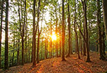
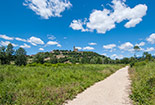
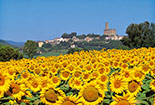
The Casentino, a territory of eastern Tuscany, is marked by the course of the Arno which has its source on Mount Falterona, in the northern part of this valley which is enclosed by the Tuscan-Romagna Apennines and two of its buttresses: the Pratomagno massif and the Alpe di Catenaia. With these geographical characteristics, it is clear that the Casentino is within a large green lung represented by thousands of hectares of woods. In this natural environment there is a grid made up of hundreds of kilometers of paths able to satisfy every desire for trekking or relaxing walks.The valley floor, crossed by the Arno and many of its tributaries, is mainly agricultural land. This determines a great change of colors over the seasons. This beautiful choreography is crossed by many paths where you can take pleasant walks. Among these are the cycle and pedestrian paths that flank the course of the Arno, the Archiano stream (towards Camaldoli) and the Teggina stream (towards Pratomagno). These paths give the opportunity to move between the characteristic villages of the valley, almost all of medieval origin.Another reason makes it interesting to walk in this Tuscan land. In the Middle Ages, between the early years of the 1000s and the beginning of the 14th century, the Casentino area met world famous personalities: Guido Monaco (inventor of musical notation), San Francesco, Dante Alighieri. It is possible to hypothesize, with limited possibility of error, on which paths these great figures have moved. Walking in their footsteps will certainly be a thing of great charm. Click on the banner for the description of the proposed itinerary.


Itinerary 2, Camaldoli Monastery area, Tuscany: chestnut groves and Camaldoli monastery, visitor center of the National Park, Nature Trail up to the Miraglia chestnut, return to the monastery. About 4 kilometres, total height difference 250 metres.


Itinerary 4, Falterona area: Passo di Piancancelli, Monte Falco, Monte Falterona, source of the Arno, Lago degli Idoli, Montelleri meadows, Monte Falco, Piancancelli. Approximately 15 kilometres, overall height difference almost 1200 metres.


Itinerary 6, Verna area, Tuscany: Chiusi della Verna, Orti della Verna, Scogliera delle Stimmate, Sanctuary of La Verna, Cappella di Fondo, Bosco delle Fate, Chiusi della Verna. About 5 kilometers, almost 400 meters of total altitude difference.


Itinerary 8, Camaldoli area, Badia Prataglia: Visit to Badia Prataglia, by car up to Aia di Guerrino, on foot on Monte Penna. Round trip on a single path. About 3 kilometres. 230 meters of total height difference.


Itinerary 10, Badia Prataglia area, Tuscany: Il Capanno restaurant, Devil's bridge, Buca delle Fate, Crocina pass, Monte Penna, Aia di Guerrino, Fangacci pass, Il Capanno. About 10.5 kilometers. 1100 meters of total height difference.


Itinerary 12, Passo della Calla area: Calla, Il Poggione, Poggio Scali, Passo Porcareccio, Aia di Dorino, La Pietra Nature Reserve, Aia delle Guardie, Fonte di Calcedonia, Calla. About 16 kilometers. 850 meters of total altitude difference.


Itinerary 14, Passo della Calla area, Romagna and Tuscany: Calla, Burraia, Prati della Burraia, Monte Gabrendo, Poggio Sodo dei Conti, Monte Falco, return to Calla by CAI 86 and CAI 82. About 12 kilometres. 900 meters of total altitude difference.


Itinerary 16, Camaldoli area. Paths to get to know the Hermitage and the Monastery, Gioghetto Pass, Prato alla Penna, Poggio Tre Confini, the Cotozzo Refuge. Routes from 5 to 11 kilometres. From 600 to 1200 meters of altitude variation.

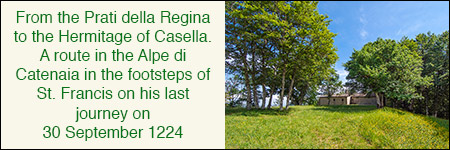
Itinerary 18, Alpe di Catenaia area. A path, in the footsteps of St. Francis, in the mountain that separates the Casentino from the upper Valtiberina. From the Prati della Regina to the Hermitage of Casella. Seventeen kilometers, but even shorter.


Itinerary 20, Alpe di Catenaia area, Tuscay, Arezzo. A short journey of less than half an hour (one way) which through a luxuriant forest leads us to the bank of a beautiful stream where there is a thermal spring: the Ferruginous Water of Chitignano.
Guido Monaco, creator of modern musical notation, certainly walked on the southern slopes of Pratomagno between 1025 and 1030. He will ideally guide us on some routes in this area immersed in beautiful nature and rich in history.
Route 2 Pratomagno: 9 kilometer itinerary. Active height difference of 500 metres. In the area between Monte di Loro and Cima Bottigliana.

Route 4 Pratomagno: 11 kilometer itinerary in the Uomo di Sasso area, Varco di Gastra. Total altitude difference 760 metres.


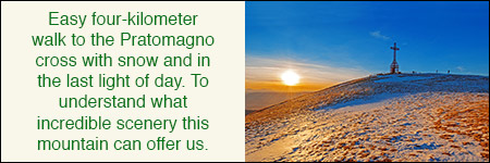
Route 6 Pratomagno: 4 kilometer walk to enjoy the charm of this mountain when the fog covers Casentino and Valdarno.


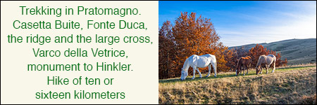
Route 8 Pratomagno: 13 kilometer itinerary of medium-high physical effort starting from Rocca Ricciarda and climbing to the large cross.


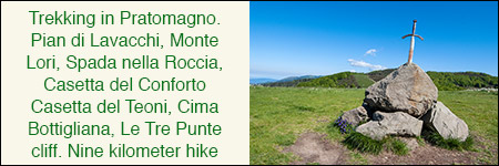
Route 10 Pratomagno: itinerary of 13.5 or 21 kilometer from Trappola to the Le Tre Punte cliff, Cima Bottigliana and Santa Trinita.


Route 12 Pratomagno: the itinerary that starts from Pontenano, arrives at Badia Santa Trinita and goes up to Poggio la Cesta. 12.5 km.


Route 14 Pratomagno: some paths of various lengths in the Faltona area to get to know the characteristic villages of this mountainous area.

Ilbelcasentino.it is a realization of:
Alessandro Ferrini, 52010 Talla (AR) - P.Iva 01428280513
Tel. 339.4257840 - info@ilbelcasentino.it
All rights reserved


