Dal Varco di Anciolina a Badia Santa Trinita
itinerario da Pontenano all'abbazia benedettina di Santa Trinita e al Varco di Anciolina
Italiano
NATURA E STORIA PRESSO BADIA SANTA TRINITA 7
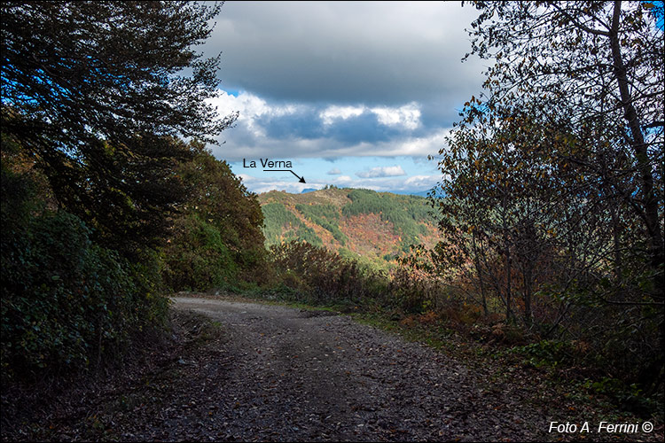
Il tratto panoramico del CAI 32 è terminato, ma davanti a noi, tra la vegetazione, abbiamo una bella vista verso nord-est. Sulla montagna di fronte ci saliremo subito dopo il passaggio da Badia Santa Trinita. Dietro, all'orizzonte, intravediamo il Monte della Verna al quale certamente non arriveremo con questa passeggiata, ma vi giungeva la Via Abversa sulla quale stiamo camminando, quando il monte era ancora ben lontano da conoscere San Francesco. Dedichiamo qualche riga a questa antichissima direttrice.
Antichissimi documenti ci parlano della Via Maior che da Buriano risaliva verso il Casentino tenendosi lungo la sponda destra dell'Arno. A Socana questa strada s'incrociava con la Via Abversa (traversa rispetto alla valle e alla Via Maior) che a destra saliva verso il Monte La Verna toccando luoghi come Taena, Rosina, Sarna (chiari toponimi etruschi). A sinistra, invece, la Via Abversa si dirigeva verso il Valdarno attraversando il Pratomagno.
Gli Annali Camaldolesi narrano che Badia Santa Trinita fu fondata tra il 950 e il 971 lungo la Via Abversa. Questa informazione ci fornisce una precisa indicazione sulla direzione che aveva questa strada. Se poi consideriamo che poco a monte di Santa Trinita si trova un fosso ancor oggi chiamato "della Via Traversa" (nome riportato anche su una mappa catastale del 1824, lo attraverseremo con questa passeggiata), questo toponimo è un'altra precisa indicazione da dove passasse questa strada. Sul tratto del Pratomagno la Via Abversa rappresentò sicuramente il collegamento diretto tra due importanti siti etruschi: Socana e Gropina. Nel primo si può ammirare una grande ara sacrificale del quinto secolo a.C. Dopo il periodo etrusco e romano, Socana e Gropina hanno conosciuto due chiese altomedievali, altre due del X secolo e le attuali pievi romaniche del XII secolo.
The panoramic stretch of CAI 32 has ended, but in front of us, among the vegetation, we have a beautiful view towards the north-east. We will climb the mountain in front of us immediately after passing by Badia Santa Trinita. Behind, on the horizon, we glimpse Monte della Verna which we certainly will not reach with this walk, but the Via Abversa on which we are walking reached it, when the mountain was still far from knowing San Francesco. Let's dedicate a few lines to this very ancient route.
Very ancient documents tell us about the Via Maior which from Buriano went up towards the Casentino keeping along the right bank of the Arno. In Socana this road crossed with the Via Abversa (a crossroads with respect to the valley and the Via Maior) which on the right went up towards Monte La Verna touching places like Taena, Rosina, Sarna (clear Etruscan toponyms). On the left, however, the Via Abversa headed towards the Valdarno crossing the Pratomagno.
The Camaldolese Annals tell us that Badia Santa Trinita was founded between 950 and 971 along the Via Abversa. This information provides us with a precise indication of the direction that this road had. If we then consider that just above Santa Trinita there is a ditch still called "della Via Traversa" (a name also reported on a cadastral map of 1824, which we will cross with this walk), this toponym is another precise indication of where this road passed. On the Pratomagno stretch, the Via Abversa certainly represented the direct connection between two important Etruscan sites: Socana and Gropina. In the first one you can admire a large sacrificial altar from the fifth century BC. After the Etruscan and Roman periods, Socana and Gropina had two early medieval churches, two others from the tenth century and the current Romanesque parish churches from the twelfth century.


